Saturday 6 November 2010

Everest View Trek 6-19 Nov 2010


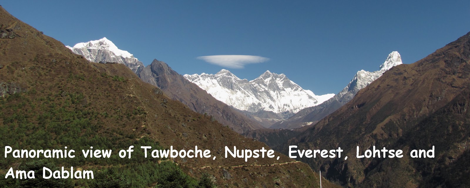
PANORAMIC VIEW OF TAWOCHE (6495m asl), NUPTSE (7861m asl), EVEREST (8848m asl), LHOTSE (8516m asl) AND AMA DABLAM (6856m asl)


Twelve of us flew into Kathmandu Tribhuvan International Airport on the morning of 6.11.2010. The following morning, we 'chartered' an Agni plane to fly us to Lukla to begin our Everest View Trek which took us from Lukla to Tengboche and return as shown in the map.

Image Hosting by PictureTrail.com

Our Route Map


The trek which took us 8 days could be graded as easy to moderate. None of us suffered from any limb muscle cramps or foot blisters. We managed to view the magnificent mountains especially the Everest and Ama Dablam fortunately at Namche Bazar and Syangboche area. We missed views at Tengboche for the weather was too misty. The return trek from Tengboche was pleasant and easy though many of us had started to develop the Khumbu cough possibly due to the dust coupled with cold air and drinking cold water. Of course, many of us enjoyed shopping for gears at Kathmandu and Namche Bazar.

Along the way back to Lukla, we heard the unpleasant news that many tourists had been stranded in Lukla as the airport was closed to commercial planes most of the time due to the inclement weather. No plane came from Kathmandu on 15.11.2010, our flight departure date and we had to start queuing for the next available seats. The queuing system was elusive and incomprehensible! Fortunately, our agent was resourceful enough to find helicopter seats to fly us out in three batches on 17 & 18.11.2010 to enable us to catch our plane home on 19.11.2010. Later on, we heard that the Nepalese military helicopters stepped in to ease the tension by rescuing the stranded tourists on 20.11.2010.

Trekking buddies who made the trip memorable were Choo, Wai Chin, Engu, Yeoh, Koon Kong, Poh Lian, Mee Hong, Nicole, Ong, Tessie and Christina

Here is the popular Nepalese Rhesem Phiriri song. Click on the green bar and the slideshow icon (on the right) to enjoy song and the photographs which are taken and arranged in chronological order.

Praveen Gurung's Thet - Resham Phiriri .mp3
Found at bee mp3 search engine

For the photographs, please refer to:
6-8 Nov 2010 Part 1 http://happytrekker.shutterfly.com/pictures/13598
9-10 Nov 2010 Part 2 http://happytrekker.shutterfly.com/pictures/13772
11-13 Nov 2010 Part 3 http://happytrekker.shutterfly.com/pictures/13979
14-19 Nov 2010 Part 4 http://happytrekker.shutterfly.com/pictures/14165

Sunday 17 October 2010

Gunung Kledang 17 Oct 2010


This is our maiden hike to Gunung Kledang, located at Taman Rasi Jaya, Menglembu.

Leaving PJ at 6 a.m., we hit Kampar at 8.15 a.m. for breakfast and marketing for packed lunch before heading towards Menglembu. By the time, we reached the head trail of Gunung Kledang at 10 a.m. and the place was almost deserted except for a few people returning from their morning walk/jog.

We started our trek about 10.15 a.m. The first 15 minutes of the trek was unbearably hot as the trail was exposed and there was little shade. It appeared that the right side of the trail had been stripped bared of trees for developmental purposes. There were also concrete steps at certain section of the trail.

At about 11 a.m. we came upon a stream with a small pool on the right side of the trail. We were advised to cross to stream to take the trail to the peak. The trail was tagged as RTM trail. From here, it was a steep climb all the way up to the peak. It was impossible to get lost for there were so many RTM markers along the trail. Enroute to the peak we made two rest stops at 380m asl and 600m asl. The trail got steeper as we approached the peak. It was about 1 p.m. when we hit the peak – almost 3 hours climb in the sweltering heat.

The views from the peak were certainly rewarding.

After our customary group pictures and lunch, we left the peak at 1.40 p.m. via the tar road. Along the way, we encountered a few species of nepenthes plants and wild orchids. Many gazebos also dotted the road for people to rest and admire the city views of Ipoh and its surrounding areas. Surprisingly, we took 3 hours to walk down to the base in that hot afternoon.

Overall, it was a good trek despite the horrible heat due to the pleasant company of Ben, Yeoh, Christina, Choo, Wai Ching, Engu, Kathy, Ong, Lim, Ah Kuai and Tai Hup as trekking buddies.


For the photographs, please refer to http://happytrekker.shutterfly.com/pictures/9177.

Sunday 10 October 2010

Gunung Angsi 10 Oct 2010


This is my 9th trip to Gunung Angsi. My last trip was on 25 April 2010 (see http://happyotrekker.blogspot.com/2010/04/g-angsi-25-april-2010.html).

Leaving PJ at 7.45 a.m. we reached Bukit Putus trail head at about 9.15 a.m. including a pit stop at Seremban Jaya for breakfast. The road landscape from Senawang Toll towards Bukit Putus has changed dramatically. One needs to be alert! After exiting from Senawang Toll, we came upon a huge cross junction after travelling about 10 minutes. This cross junction has replaced the old T junction with the left road leading to Seremban and the opposite new Lekas road to K Pilah. We took the right turn to Bukit Putus (old Kuala Pilah road).

We took about 2.5 hrs to hit the peak and 2 hrs to return to trail head. The trek was uneventful but the weather was beautifully conducive – breezy and cool. There were hardly any mushrooms as the trail was dry. But ginger plants and flowers were plentiful. Going up, we met a man carrying a huge plastic load of rubbish downhill. Kudos to him for cleaning up rubbish left by the campers!

On our way home, we stopped by the first campsite and helped ourselves with the free tongsui, courtesy of Koh Loh. The tongsui was tasty and fragrant with ginger for sweet potato tongsui and dried mandarin orange peal for green bean tongsui. In appreciation of Koh Loh’s contribution, earlier we have donated 1 kg of red beans and 1 kg of sugar.

Overall, it was a good energetic and pleasant trek.

Trekking buddies were Christina and Engu. At the peak we had a chance to touch base with trekker friends, namely Wun and Helen.

For the photographs, please refer to http://happytrekker.shutterfly.com/pictures/9099.

Thursday 16 September 2010

Gunung Tok Wan Broga 16 Sep 2010


The last trip to Broga Hill, about 50 km from Petaling Jaya, was on 14 November 2009 (see http://happyotrekker.blogspot.com/2009/11/broga-hills-14112009.html).

On arrival, we saw more than 50 motor vehicles parked in the old oil palm estate which has been converted into a huge open car park area. Based on this, we estimated at least a hundred hikers in the hills.

At 7.50 a.m., it was quite a task getting through the long queue of people lumbering downhill. We took about 1 hour to reach the Broga peak (400m asl) at 9:05 a.m. A few adventurous youngsters have even resorted to sliding down the lalang slope to beat the queue heading home.

From Broga peak, we had to enter the forest to trek to Gunung Tok Wan (675m asl). We took about 2 hours to trek the undulating trail and hit the peak at 11 a.m. The dense tree canopy provided us much shade against the harsh mid-day sun that day.

After spending an hour, we started to back trek at 12 noon. We literally raced down the Broga trail to minimize exposure to the hot sun and hit the base at 2.15 p.m. Thereafter, we adjourned to Lim Sak Chan’s stall to cool down ourselves with his famous ABC.

Pleasant trekking buddies included Kathy, Ann, Yeoh, Tessie, Terry, Jean, TQ, Christina, Chew and Siew Kim.


Image Hosting by PictureTrail.com


For the photographs, please refer to http://happytrekker.shutterfly.com/pictures/7997.

Sunday 12 September 2010

Gunung Gap & Ulu Semangkok 12 Sep 2010


On 12 September 2010, we travelled 100 km east to Gap, a small town station located at 825m asl at the base of Bukit Fraser's Hill with the aim of exploring Gunung Gap (GG) as well as Gunung Ulu Semangkok (GUS). Leaving Petaling Jaya at 5.30 a.m. we stopped by Rawang at 6 a.m. to have breakfast before proceeding to the head trail of GG. The trail head which is located opposite the 91km KL milestone was easy to locate.

Starting at 8.20 a.m. we took about an hour to hit GG peak (1,140m asl) at 9.20 a.m. It was a steep climb all the way to the peak. The trail was quite clear and covered with dried leaves. After a short break at the peak, we took the 9 o’clock trail downhill towards GUS. The undulating trail comprises 3 steep ascents before the GUS peak (1,340m asl). We took about 2 hours to hit the peak at 11.20 a.m. There were a lot more varied flora like moss, wild orchids and mushrooms along the way to GUS. However, there was no view from GUS compared to GG where we could at least have two limited views of the surrounding regions.

We left the peak at 12 noon and reached the base at 2.10 p.m. The return trek was indeed a very challenging on the knees especially the section from GG peak.

Overall, it was a good energizing trek in the cool highland particularly in the pleasant company of trekkers Kathy, Anne, Tessie, Yeoh, Engu, Ong, Ben, Christina and Yip.

For the photographs, please refer to http://happytrekker.shutterfly.com/pictures/7995.

Sunday 15 August 2010

Gunung Mentigi 15 Aug 2010


HABU VALLEY in the afternoon sun

Vibrant star-like MOSS near the peak area

BUKIT MENTIGI HOUSES flanked by G Beremban on the right and G Brinchang at 11 o'clock


Gunung Mentigi or Rhododendron Mountain (Mentigi is the Malay name for 'rhododendron') was our next target after Gunung Irau (http://happyotrekker.blogspot.com/2010/02/gunung-irau-29-31-jan-10.html), Gunung Beremban (http://happyotrekker.blogspot.com/2010/07/gunung-beremban-4-july-2010.html), Gunung Jasar and Gunung Perdah (http://happyotrekker.blogspot.com/2010/07/gunung-jasar-gunung-perdah-25-july-2010_26.html).

Apart from the trail information provided by the various tourist maps for Cameron Highlands, we were unable to glean any comprehensive reports of Gunung Mentigi trek from the internet. Nonetheless, we decided to proceed with our trip. We would say this recce trip really tested our group’s indomitable spirit to complete the mission.

Finding the trailhead of Trail 13 near the Veterinary Services Department (VSD) along Persiaran Dayang Endah (PDE) was easy but finding the entrance of the trailhead was a challenge for it was hidden by thick undergrowth. Less than 5 minutes into the trail, we were confronted by a vast area cleared for vegetable farming. In short, the trail had “disappeared”. The residents told us that the trail was no longer being used and directed us to use another access further down PDE towards the hospital. Travelling down the road, we encountered many parked vehicles along a slip road on the right. The trail board there indicated Trail 9 which is supposed to lead to Robinson Waterfall. After trekking for 15 minutes, our misgiving started to arise and we decided to back trek. This time we decided to explore another trailhead to Trail 13 located behind Cameronian Holiday Inn (CHI), Off Jalan Mentigi. We unable to locate the trailhead and a well-informed resident told us that the trailhead had been “lost” to development. We saw earthwork had begun on a vast tract of land behind CHI area.

After 3 false starts, the group’s patience was wearing thin and there were suggestions to trek Gunung Beremban again. It was already 10.30 a.m. when we decided to check out our original plan to trek from the VSD notwithstanding the discouragement by the local residents living and farming there. Heading up the farm, a local resident (sensing our persistence), pointed out a dense forest opening, along the farm perimeter, to Trail 13. The opening was covered with thick undergrowth and nearly impenetrable. We saw a trace of path among the forest vegetation and one of our brave members volunteered to venture into the thick and dense opening to explore. Within a minute, we heard a call that there was a clear trail.

It was 10.50 a.m. when we started our trek. The trail was clear but thick with fallen leaves. The jungle vegetation was generally damp due to the rainy season. Ten minutes later, we came across a yellow signboard which had been displaced from somewhere. We were unable to interpret the signboard as it was badly defaced. Just beyond the signboard, about 10 meter away, the trail came to an abrupt end as a result of earthwork being carried out for another development. We believe the earthwork extended from the “destroyed” trailhead of Trail 13 starting from CHI. Fortunately, we noted an uphill trail, presumably Trail 14 on the left about 2 meters before the end of the trail. From here, it was all the way uphill until we hit the peak at 1,494m asl (official: 1,535m) at 11.50 a.m. Along the way, we saw 2 trails branching off on the right. One of these could lead south towards Habu region. At the peak, there was an iron structure, possibly the remnant of the trigonometrical station and a stone pillar. The view from the peak area was good. As expected, the vegetation near the peak area was stunted and sparse as well as mossy. Giant nepenthes plants were also sighted.

After a good rest, we proceeded downhill at 12.10 p.m. using another trail from the peak area. This trail crept steeply downhill for 10 minutes before it came to an open cut slope facing Bukit Mentigi housing area. We resorted to using the rainwater canal to descend for a short distance before exiting through a visible jungle trail towards the housing area where we reached at 12.50 p.m.

Overall, we were satisfied after having accomplished our mission. The most memorable part of the trek was the scenic view from the peak, the giant Nepenthes plants as well as the beautiful star-like carpet moss. The weather was gloomy but luckily, the rain held off until the end of our trek. Our only concern was that the access to Trail 14 from the north side would be lost soon based on the rate of development encroaching on Trail 13.

Great trekking buddies included Yeoh, Engu, Ong, Wai Ching, Choo, Jamie, Careen, Murugiah, Kanchana and Ben.


Image Hosting by PictureTrail.com


For the photographs, please refer to http://happytrekker.shutterfly.com/pictures/7991.

Sunday 1 August 2010

Lepoh Waterfall 1 Aug 2010


In February 2010, the jungle and the surrounding areas were parched dry and appeared lifeless with little activities. The trail was unkempt with thick undergrowth closing in and fallen tree trunks blocking the way. See report at http://happyotrekker.blogspot.com/2010/02/sg-lepuh-fall-2122010.html

Now the place was alive with activities for it was fruiting season for durian, langsat, mangosteen, chempedak and rambutan. The broken bridge which encountered during my last trip in February 2010 had been repaired. The trail had also been widened and cleared to facilitate transport of orchard produce. Along the way to the waterfall, we encountered many group of picnickers, trekkers and students as well as Temuan residents transporting durians from the interior. The only downside was the super slippery wet trail. Of course, leeches made their presence along the trail as well as at the waterfall area.

Starting at 9.30 a.m. we took our time to savor the lush forest trail and reached the waterfall at 12 noon with a stop-over of 30 minutes to enjoy a durian feast at a Temuan hut. The waterfall area was congested and finding a shady place to rest was a challenge. We left the place at 12.50 p.m. and reached the base at 2.50 p.m. Needless to say, we stopped by the fruit stalls along the Ulu Langat road to eat as well as buy durians, rambutans, mangosteens, chempedaks, duku langsats and dukongs.

Overall, it was an enjoyable trip with trekking buddies including Yeoh, Engu, Ong, Wai Ching, Su Lung, Choo, Christina, Jane, Suan Li, Melinda and Sen.

For the photographs, please see http://happytrekker.shutterfly.com/pictures/7992.


The last trip was on 21 February 2010 (http://happytrekker.multiply.com/photos/album/293/Sg_Lepuh_Fall_21.2.2010).

Sunday 25 July 2010

Gunung Jasar & Perdah 25 Jul 2010


Summit view from Gunung Jasar

Summit view from Gunung Perdah

We left PJ at 5.15 a.m. in 2 vans and 1 car carrying a total of 22 trekkers. As usual we stopped by Bidor wet market to have our breakfast before leaving for Tanah Rata. It was about 9.20 a.m. when we finally arrived at Tan’s Camelia Garden (TCG), the access point to the head trail to Gunung Jasar and thereafter to Gunung Perdah.

From the Main Gate of TCG, we followed the cemented pathway till we reached a T-junction. Here we took the left turn to the trail head. The path wound gently uphill and slowly merged into a jungle trail. Starting at 9.40 a.m. and following the main wide trail (ignoring all subsidiary branch trails), we came across the first signboard entitled Jungle Walk 11 at 10 a.m. This stretch of trail was relatively flat. Just beyond the signboard, there were 3 more signage, though highly defaced, we were able to make out that the left split was Trail 10 to Gunung Jasar and the right split was Trail 11 to Gunung Perdah.

We took the left trail which went all the way uphill. Along the way, we saw moss, ferns and mushrooms as well as wild orchids. About an hour later, we came to an open area with a full view of a transmission tower. Much forest destruction could be seen here. The slope to the peak was cut (for construction of transmission tower?) and devoid of trees except for lalang vegetation. Authorities appeared to have planted seedlings and used plastic sheet to prevent further soil erosion. Here onwards, we followed whatever footholds along the cut slope and reached the Gunung Jasar peak (1670m asl official) about 11.30 a.m. The view from the peak was scenic.

After spending about 20 minutes, we left the peak at 12 noon by taking a downhill trail on the right to Gunung Perdah. There was another downhill trail on the left which we presumed would lead to Bharat Tea plantation (Trail 6). For the next 45 minutes, it was all the way downhill until 1465 m asl before the trail started to ascent again. The ascent was a short 15 minutes climb to the peak of Gunung Perdah (1,535m asl official). Minutes before the peak, the trail split into 2; the left trail would go downhill to the Orang Asli settlement while the right trail would lead to the peak. The peak area was much bigger and offered a near 360 degree scenic view of the surrounding areas. With the absence of any tree canopy, the peak was indeed hot at 1 p.m!

From the peak, we took the right trail downhill in order to return home. The downhill trail was partially destroyed as the slope was also cut (slope conservation due to development at the lower level occupied by Tenaga Station?). Upon reaching the bottom, we discovered a signboard showing the direction of Trail 12. But we were not able to make out Trail 12 through the cut slope! Not confident, we sought the assistance of a few Orang Asli kids who sportingly showed us an alternative route around the perimeter of Tenaga Station and an old laterite road running uphill besides the transmission tower.

After trekking 15 minutes uphill along the old laterite trail (Trail 11 possibly obliterated by this old laterite trail used for the erection of transmission tower), we came across a turning on the left carrying the Jungle Trail 11 signboard. The entrance to Trail 11 was quite obscure and covered with grass, lalang and fern plants. We had to wade through thick undergrowth for 5 minutes until we came to a clear neat trail, believed to be the original Trail 11. From here, it was an easy trek along a relatively flat trail, transverse occasionally by small trickling streams. It was about 3 p.m. when we were back to the original junction of Trail 10 and 11 where we waited for another 30 minutes for the last trekker to arrive before departing at 3.30 p.m. for TCG, which took us another 15 minutes to trek. After washing up (20 sen for use of toilet) at TCG, we left the place happily at 4 p.m. As usual, we stopped by Restoran Hao Yi Lou, Tapah to have dinner en route home.

Overall, a great trek in a pleasant company of 21 trekking buddies, namely Elsie, Yeoh, Engu, Ong, Chris Goh, Koon Kong, Mee Hong, Ji Ven, Steven Loh, Siew Fang, Ben, James Ong, William Chin, Cheh, Ho, Catherine Lim, Peter Lim, Robbin, Jamie Soon, Leong and Jamie Yeoh.

Image Hosting by PictureTrail.com


Our route Trail 10 --> Trail 11 --> Trail 10

For the photographs, please refer to http://happytrekker.shutterfly.com/pictures/7989.

Sunday 4 July 2010

Gunung Beremban 4 Jul 2010


Leaving PJ at 5 a.m., we reached the trail head at about 9 a.m. with a 30 minutes stopover for breakfast at Bidor wet market. There are many routes to Gunung Beremban, Cameron Highlands. We decided to take the shortest Trail 5 which starts from behind MARDI staff quarters. A security guard at MARDI was kind to direct us to the trail head which is situated on top of a hill accessible via a good tar road. The trail head was clearly marked with the standard yellow signboard above a short flight of steps located between two rows of single storey houses.

We had to bypass vegetable plots before entering the forest trail. The entrance to the forest trail was slightly obscure but easily detectable. Starting at an elevation of 1,374m asl at 9.15 a.m. we took about 2 hours to hit the peak situated at 1,757m asl (official: 1,812m asl). The first 1 hour was an easy trek along a relatively gentle uphill slope to a pavilion rest stop at elevation 1,505m asl. The trail was wide and neat. Trekking was pleasant due to soft cushioning effect of the mossy trail. After the pavilion rest area, it was all the way uphill for the next 45 minutes when we hit the trigonometric station at 11.10 a.m. This section of the trail consisted of red laterite soil held together by tree roots.

The weather was beautiful and we had a clear view of Tanah Rata and Brinchang towns from the peak. We took some time to explore an alternative trail behind the trigonometric station. The alternative trail split into 2 trails: Left Trail 8 to Robinson waterfall and right Trail 7 to Mini tea plantation beside MARDI.

After the usual snack time and photography break, we left the peak at 11.45 a.m. This time we decided to explore Trail 6 home upon reaching the Pavilion Rest Area. We took less than 2 hours to trek from the peak to the Forestry Department, which is the trail head for Trail 6 to Gunung Beremban. Except for one step descent and 2 steep ascents, after the Pavilion Rest Area, the trail was relatively simple to trek. When we reached the Forestry Department at 1.35 p.m., we found that the ever thoughtful and resourceful Ben had gone ahead to thumb a lift from a kind gentleman to Mardi trail head to collect his vehicle in order to fetch us from the Forestry Department.

We left the place at 2 p.m. and reached PJ at 7 p.m. with an hour break for early dinner at Hao Yi Lou, Tapah for RM8 pax.

Trekking buddies: Ben, Murugiah, Kanchana, Chua, Jackie, May, Siew Ngoh, Elsie, Yip and Yeoh.

NB: This mountain Gunung Beremban (1,812m) is different from the higher Gunung Berembun (2,076m) situated in Terengganu.

Image Hosting by PictureTrail.com


For the photographs, please refer to http://happytrekker.shutterfly.com/pictures/7987.

Thursday 1 July 2010

Upper Ah Pak San Waterfall 1 Jul 2010


Started at 9.30 a.m. we took more than 2 hours to reach the Upper waterfall aka Wow-Wow waterfall. It was a weekday, so we literally had the waterfall area to ourselves. The water flow was strong and refreshingly cold. We left the place at 12.30 p.m. and reached the base at 2.15 p.m.

Trekking buddies: Joyce, Sara, Justina, Kay Hwa and Leng-lei

For the photographs, please refer to: http://happytrekker.shutterfly.com/pictures/7985.

The last Upper Ah Pak San Waterfall was on 1 March 2009 (http://happyotrekker.blogspot.com/2009/03/upper-ah-pak-san-waterfall-1309_3.html).

Sunday 13 June 2010

Gunung Datuk 13 Jun 2010


My last trip to Gunung Datuk was exactly 1 year ago on 13 June 2009. Like June a year ago, the weather was extremely hot and as usual we were literally bathing in our own sweat. Nothing much has changed. This gunung remained as popular as ever. The view from the famous gigantic rock outcrop was clear and good. The trail was patched dry and easy to trek. We took about 2 hours to hit the summit and 1 1/2 hours to return to base. On the downside, the forest was less vibrant. Nevertheless, it was a good fun hike, especially with great trekking buddies Ben, Barbara, Murugiah, Kanchanna, Wai Ching, Engu, Yeoh, Ong, Christina, Randy, Ting, Nicole, Koon Kong, May and Yip.

We ended our trek with a late afternoon lunch at Restoran Happy Seng Kee. The food was good and price reasonable at RM12 pax for 5 dishes of fish, vegetables, taufoo and chicken.

For the photographs, please refer to http://happytrekker.shutterfly.com/pictures/7982.

Photos of previous trips can be viewed at:
1) http://happyotrekker.blogspot.com/2009/06/gunung-datuk-13-june-09_14.html
2) http://happyotrekker.blogspot.com/2009/02/g-datuk-140209.html
3) http://happyotrekker.blogspot.com/2008/03/gunung-datuk-2032008_20.html
4) http://happyotrekker.blogspot.com/2007/03/gunung-datuk-1832007_19.html

Sunday 6 June 2010

Gunung Bujang Melaka 6 Jun 2010


Eight of us, packed in one van, left Petaling Jaya at 5.15 a.m. We hit Bidor at about 6.50 a.m. where we had an early breakfast at the famous Pun Chun restaurant. We managed to reach the trail head at 7.40 a.m. There we found the trek leaders, Ming and Lim from Kampar waiting patiently for us. Quickly, we geared ourselves and started walking uphill along Jalan Batu Berangkai of Taman Ros at 7.45 a.m. The starting elevation was noted as 50m asl.

Along the way, we passed by scenic kampung houses and the infamous Batu Berangkai Waterfall which had claimed many lives (the recent case were 3 varsity students in November 2009). The water flow was indeed strong and impressive. It is a nice and pleasant area to relax and picnic. As we were running behind, we could not spare much time to enjoy the waterfall.

From the waterfall, we followed a narrow tar road for about 15 minutes before it ended in a jungle trail. Following the jungle trail, we by passed an orang asli house at 8.45 a.m. The trail snaked gently uphill for the next 1 hour to Campsite 1 situated at elevation 452m asl. The next 2 hour involved a very challenging climb of 520m to the Campsite 2 (970m asl). We even had to pull ourselves up a collapsed slope by grabbing onto roots and tree branches.

After a good 30 minutes rest, we started from the second campsite at 12:20 p.m. We took 1:20 hours to transverse 3 small hills to reach the peak (1234m asl) at 1.40 p.m. Notwithstanding a few fallen tree trunks whereby we were required us to do some crawling, this section of the trail was relatively easier. There was a small view of the Chendariang town. Unfortunately, it was obscured by a thick mist at that time.

We left the peak 10 minutes to 2 p.m. and reached the base at 6 p.m.

Overall, it was a very challenging day hike. The muggy weather that day really sapped a lot of energy from us. Luckily, it did not rain. Otherwise, it would be extra challenging to have to manage slippery trail.

Trekking buddies from KL: Ben, Muru, Khanchana, Randy, Ting, Cheh and Lee Lian.

For the photographs, please refer to http://happytrekker.shutterfly.com/pictures/7980.

Sunday 25 April 2010

Gunung Angsi 25 Apr 2010


The last hike to G Angsi was in May 2009 (http://happyotrekker.blogspot.com/2009/05/gunung-angsi-24-may-09_25.html).

After Senawang, the drive to Bukit Putus trunk road was a breeze without a single motor vehicle in sight. From the head trail, we could look down and watch vehicles tearing down the newly constructed Seremban- Kuala Pilah highway which runs almost parallel to the old trunk road. Hopefully, the local authorities would continue to maintain the trunk road.

Starting at 8.40 a.m. we took a slow trek to fully enjoy the beautiful windy weather and the forest,"fresh" and "alive" possibly due to a heavy rainfall the night before. We noted that someone has thoughtfully put up signboards for the direction to G Angsi (using the easy route) as well as areas of interest. We hit the peak close to 12 noon after 3 hours trek.

After a good rest and refreshment, we descended at 1 pm and arrived at the base at 2.40 p.m.

Trekking buddies are Choo, Janice, Wai Chin, Ong & Yeoh.

For the photographs, please refer to http://happytrekker.shutterfly.com/pictures/7999.

Saturday 10 April 2010

Gunung Tampin 10 Apr 2010


Despite the heavy thunderstorm since 5 a.m. in PJ, we still decided to go ahead with our plan to hike Gunung Datuk. It was raining heavily throughout our road journey but we hoped the rain would stop when we approached G Datuk. True enough the rain did stop, but we our hope was dashed when we realized that there was on going G Datuk Challenge event. Judging by the numerous vehicles (including buses), the crowd must be big. So we decided to head for G Tampin. Luckily, our car was fitted with a GPS – a mighty useful tool which led us towards G Tampin and a nice local resident took time to show us the way to the trail head which is located in Kg Seri Tampin.

Starting at 9.40 a.m. we did a slow walk up the winding tar road to the summit. Along the way, there were several covered rest areas. After about 30 minutes, we reached a recreation spot equipped with a changing room and a pool. At 11 a.m. we were greeted by a huge satellite dish carrying the Telekom logo at the peak. The walk was uneventful but pleasant given the thick canopy which provided much shade and the cool weather after the morning shower. We only met 3 hikers along the way.

After a short photography session at the peak, we left at about 11.30 a.m. and hit the base at 12.15 a.m. We then headed for Melaka for some shopping and to savour the famous chicken rice balls for lunch.

The return car journey was horrendous for our car was caught in 1-hour jam before the Sg Besi Toll Gate. After paying the toll, we were allowed to make a U-turn to find another exit from Seremban Hwy via UPM. We attributed the jam to the numerous vehicles (buses and cars with N9 banners) ferrying fans to the Malaysia FA Cup final between N9 and Kedah.

NB: For location of G Tampin, see http://travelingluck.com/Asia/Malaysia/Negeri+Sembilan/_1741882_Gunong+Tampin.html#local_map. Take the road that turns off the main road into Kampung Seri Tampin. The trail head is located at the end of this road.

Trekking buddies: Nicole, Mee Hong, Xiung, Aun Pein and Sziang Meng.

For the photographs, please refer to http://happytrekker.shutterfly.com/pictures/7939.

Sunday 7 March 2010

Sg Chiling 7 Mar 2010


The last trip was more than 2 years ago on 27.2.2008 (http://happyotrekker.blogspot.com/2008/02/sg-chilling-2722008_27.html).

Sg Chiling was as popular as ever with trekkers, picnickers and photographers. Starting at 8.30 a.m. we took a slow trek of 1.5 hours to reach the waterfall at 10 a.m. The trail which curved along the riverbank was flat and easy to trek. There were clear signboards showing where to cross the river. River crossings were easy as the water level was low obviously due to the dry spell. Generally, the place was as pristine as ever though the water was a little milky. The weather was pleasant enough for us to laze around without having to seek out shelter against the sun. We left the place at 12 noon and reached the head trail at 1 p.m. Along the way, we met more people indicating the popularity of the place.

Overall, an easy relaxing hike.

Trekking buddies: Horng Yih, Joo Wee, Choo, Kathy, Yeoh, Engu and Leng-Lei.

For the photographs, please refer to http://happytrekker.shutterfly.com/pictures/7495.