Sunday, 30 January 2011

Broga Hills 30 Jan 2011


My last trip to Broga Hills was on 16 Sep 2010 (http://happyotrekker.blogspot.com/2010/09/gunung-tok-wan-broga-1692010.html)

It was a beautiful Sunday dawn when we left PJ at 6.30 a.m. and headed towards Broga Hill. Our joy was however short-lived when it started to drizzle while we were approaching Broga Hills at 7.30 a.m. Ever as adventurous, we decided to proceed with the trek notwithstanding the drizzle.

The view was super misty and the terrain was super slippery. By the time we hit the first peak, the drizzle has gave away to light rain. We then decided to abort our original plan to trek to Gunung Tok Wan but to proceed to the final Broga peak and returned via the plantation way.

We made it to the final Broga peak in good time at 8.55 a.m. After 10 minutes of refreshment, we proceeded into the jungle to find the plantation trail home. The plantation trail was obscure and covered by thick undergrowth. Obviously, this trail was no longer popular with hikers and it has been more than 2 years since we last trekked the plantation route. Fortunately, we were able to dig deep into our memory to recall several key landmarks to find our way downhill. We reached to the base safely, though very wet, at 10.25 a.m.

This wet adventurous trekking trip was shared with sporting buddies Elsie, Yeoh, Choo, Natalie, Terry, Sarah, Angie and Wendy.

For the photographs, please refer to http://happytrekker.shutterfly.com/pictures/9236.

Saturday, 15 January 2011

Twin Peak 15 Jan 2011


Leaving PJ at about 7 a.m, our van took a slow winding drive to Gap, the gateway to Fraser’s Hill. We reached Gap at 9 a.m. in time for the uphill traffic. The journey from Gap to the head trail took only 30 minutes.

Compared to my last Pine Tree Hill Trek in 2006 (see http://happyotrekker.blogspot.com/2006/10/pine-tree-hill-2006_29.html), a lot of improvements could be seen. The entrance to the head trail of the Pine Tree Hill (PTH) has been spurned up with new bill boards and there were mileage signage as well as 4 huts enroute to the PTH’s summit. Furthermore, the trail was much clearer and not wild with undergrowth. Concrete and wooden steps together with balustrade have also been constructed throughout the major portion of the undulating trail.

Starting at 9.30 a.m. at an elevation of 1,385 m asl, we took about 3 hours to hit the PTH peak standing at 1,530m asl at 12.30 a.m. The distance covered was 5.5 km. The trail was slippery due to the wet weather. There was a fair number of clambering over and ducking under fallen tree trunks. Of course, the most challenging part was the vertical climb of over 20 meters near PTH peak. The view from PTH was vapid and limited by the shifting mist.

We had a good rest and refreshment before leaving for the Twin Peak (TP) at 1.30 a.m. The trail to TP was soft and muddy. It took us 30 minutes to hit TP which was only 1,510m asl. TP offered a better 360 degree panoramic view. We spent about 15 minutes and quickly retraced our path home given the overcast sky. We reached the base at 5.30 p.m.

Overall, it was a good energetic trek in the pleasant company of Yeoh, Ong, Ben, Muru, Kanchana, Paul, Aniza, Tracy and Teoh.

For the photographs, please refer to http://happytrekker.shutterfly.com/pictures/9316.

Saturday, 6 November 2010

Everest View Trek 6-19 Nov 2010


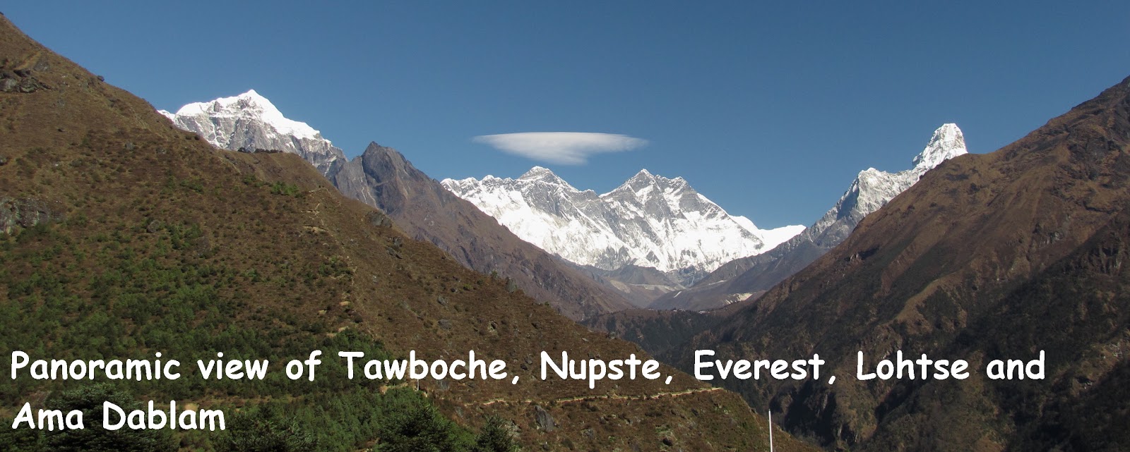
PANORAMIC VIEW OF TAWOCHE (6495m asl), NUPTSE (7861m asl), EVEREST (8848m asl), LHOTSE (8516m asl) AND AMA DABLAM (6856m asl)


Twelve of us flew into Kathmandu Tribhuvan International Airport on the morning of 6.11.2010. The following morning, we 'chartered' an Agni plane to fly us to Lukla to begin our Everest View Trek which took us from Lukla to Tengboche and return as shown in the map.

Image Hosting by PictureTrail.com

Our Route Map


The trek which took us 8 days could be graded as easy to moderate. None of us suffered from any limb muscle cramps or foot blisters. We managed to view the magnificent mountains especially the Everest and Ama Dablam fortunately at Namche Bazar and Syangboche area. We missed views at Tengboche for the weather was too misty. The return trek from Tengboche was pleasant and easy though many of us had started to develop the Khumbu cough possibly due to the dust coupled with cold air and drinking cold water. Of course, many of us enjoyed shopping for gears at Kathmandu and Namche Bazar.

Along the way back to Lukla, we heard the unpleasant news that many tourists had been stranded in Lukla as the airport was closed to commercial planes most of the time due to the inclement weather. No plane came from Kathmandu on 15.11.2010, our flight departure date and we had to start queuing for the next available seats. The queuing system was elusive and incomprehensible! Fortunately, our agent was resourceful enough to find helicopter seats to fly us out in three batches on 17 & 18.11.2010 to enable us to catch our plane home on 19.11.2010. Later on, we heard that the Nepalese military helicopters stepped in to ease the tension by rescuing the stranded tourists on 20.11.2010.

Trekking buddies who made the trip memorable were Choo, Wai Chin, Engu, Yeoh, Koon Kong, Poh Lian, Mee Hong, Nicole, Ong, Tessie and Christina

Here is the popular Nepalese Rhesem Phiriri song. Click on the green bar and the slideshow icon (on the right) to enjoy song and the photographs which are taken and arranged in chronological order.

Praveen Gurung's Thet - Resham Phiriri .mp3
Found at bee mp3 search engine

For the photographs, please refer to:
6-8 Nov 2010 Part 1 http://happytrekker.shutterfly.com/pictures/13598
9-10 Nov 2010 Part 2 http://happytrekker.shutterfly.com/pictures/13772
11-13 Nov 2010 Part 3 http://happytrekker.shutterfly.com/pictures/13979
14-19 Nov 2010 Part 4 http://happytrekker.shutterfly.com/pictures/14165

Sunday, 17 October 2010

Gunung Kledang 17 Oct 2010


This is our maiden hike to Gunung Kledang, located at Taman Rasi Jaya, Menglembu.

Leaving PJ at 6 a.m., we hit Kampar at 8.15 a.m. for breakfast and marketing for packed lunch before heading towards Menglembu. By the time, we reached the head trail of Gunung Kledang at 10 a.m. and the place was almost deserted except for a few people returning from their morning walk/jog.

We started our trek about 10.15 a.m. The first 15 minutes of the trek was unbearably hot as the trail was exposed and there was little shade. It appeared that the right side of the trail had been stripped bared of trees for developmental purposes. There were also concrete steps at certain section of the trail.

At about 11 a.m. we came upon a stream with a small pool on the right side of the trail. We were advised to cross to stream to take the trail to the peak. The trail was tagged as RTM trail. From here, it was a steep climb all the way up to the peak. It was impossible to get lost for there were so many RTM markers along the trail. Enroute to the peak we made two rest stops at 380m asl and 600m asl. The trail got steeper as we approached the peak. It was about 1 p.m. when we hit the peak – almost 3 hours climb in the sweltering heat.

The views from the peak were certainly rewarding.

After our customary group pictures and lunch, we left the peak at 1.40 p.m. via the tar road. Along the way, we encountered a few species of nepenthes plants and wild orchids. Many gazebos also dotted the road for people to rest and admire the city views of Ipoh and its surrounding areas. Surprisingly, we took 3 hours to walk down to the base in that hot afternoon.

Overall, it was a good trek despite the horrible heat due to the pleasant company of Ben, Yeoh, Christina, Choo, Wai Ching, Engu, Kathy, Ong, Lim, Ah Kuai and Tai Hup as trekking buddies.


For the photographs, please refer to http://happytrekker.shutterfly.com/pictures/9177.

Sunday, 10 October 2010

Gunung Angsi 10 Oct 2010


This is my 9th trip to Gunung Angsi. My last trip was on 25 April 2010 (see http://happyotrekker.blogspot.com/2010/04/g-angsi-25-april-2010.html).

Leaving PJ at 7.45 a.m. we reached Bukit Putus trail head at about 9.15 a.m. including a pit stop at Seremban Jaya for breakfast. The road landscape from Senawang Toll towards Bukit Putus has changed dramatically. One needs to be alert! After exiting from Senawang Toll, we came upon a huge cross junction after travelling about 10 minutes. This cross junction has replaced the old T junction with the left road leading to Seremban and the opposite new Lekas road to K Pilah. We took the right turn to Bukit Putus (old Kuala Pilah road).

We took about 2.5 hrs to hit the peak and 2 hrs to return to trail head. The trek was uneventful but the weather was beautifully conducive – breezy and cool. There were hardly any mushrooms as the trail was dry. But ginger plants and flowers were plentiful. Going up, we met a man carrying a huge plastic load of rubbish downhill. Kudos to him for cleaning up rubbish left by the campers!

On our way home, we stopped by the first campsite and helped ourselves with the free tongsui, courtesy of Koh Loh. The tongsui was tasty and fragrant with ginger for sweet potato tongsui and dried mandarin orange peal for green bean tongsui. In appreciation of Koh Loh’s contribution, earlier we have donated 1 kg of red beans and 1 kg of sugar.

Overall, it was a good energetic and pleasant trek.

Trekking buddies were Christina and Engu. At the peak we had a chance to touch base with trekker friends, namely Wun and Helen.

For the photographs, please refer to http://happytrekker.shutterfly.com/pictures/9099.

Thursday, 16 September 2010

Gunung Tok Wan Broga 16 Sep 2010


The last trip to Broga Hill, about 50 km from Petaling Jaya, was on 14 November 2009 (see http://happyotrekker.blogspot.com/2009/11/broga-hills-14112009.html).

On arrival, we saw more than 50 motor vehicles parked in the old oil palm estate which has been converted into a huge open car park area. Based on this, we estimated at least a hundred hikers in the hills.

At 7.50 a.m., it was quite a task getting through the long queue of people lumbering downhill. We took about 1 hour to reach the Broga peak (400m asl) at 9:05 a.m. A few adventurous youngsters have even resorted to sliding down the lalang slope to beat the queue heading home.

From Broga peak, we had to enter the forest to trek to Gunung Tok Wan (675m asl). We took about 2 hours to trek the undulating trail and hit the peak at 11 a.m. The dense tree canopy provided us much shade against the harsh mid-day sun that day.

After spending an hour, we started to back trek at 12 noon. We literally raced down the Broga trail to minimize exposure to the hot sun and hit the base at 2.15 p.m. Thereafter, we adjourned to Lim Sak Chan’s stall to cool down ourselves with his famous ABC.

Pleasant trekking buddies included Kathy, Ann, Yeoh, Tessie, Terry, Jean, TQ, Christina, Chew and Siew Kim.


Image Hosting by PictureTrail.com


For the photographs, please refer to http://happytrekker.shutterfly.com/pictures/7997.

Sunday, 12 September 2010

Gunung Gap & Ulu Semangkok 12 Sep 2010


On 12 September 2010, we travelled 100 km east to Gap, a small town station located at 825m asl at the base of Bukit Fraser's Hill with the aim of exploring Gunung Gap (GG) as well as Gunung Ulu Semangkok (GUS). Leaving Petaling Jaya at 5.30 a.m. we stopped by Rawang at 6 a.m. to have breakfast before proceeding to the head trail of GG. The trail head which is located opposite the 91km KL milestone was easy to locate.

Starting at 8.20 a.m. we took about an hour to hit GG peak (1,140m asl) at 9.20 a.m. It was a steep climb all the way to the peak. The trail was quite clear and covered with dried leaves. After a short break at the peak, we took the 9 o’clock trail downhill towards GUS. The undulating trail comprises 3 steep ascents before the GUS peak (1,340m asl). We took about 2 hours to hit the peak at 11.20 a.m. There were a lot more varied flora like moss, wild orchids and mushrooms along the way to GUS. However, there was no view from GUS compared to GG where we could at least have two limited views of the surrounding regions.

We left the peak at 12 noon and reached the base at 2.10 p.m. The return trek was indeed a very challenging on the knees especially the section from GG peak.

Overall, it was a good energizing trek in the cool highland particularly in the pleasant company of trekkers Kathy, Anne, Tessie, Yeoh, Engu, Ong, Ben, Christina and Yip.

For the photographs, please refer to http://happytrekker.shutterfly.com/pictures/7995.